
Le Buisson Sabot topographic map
Interactive map
Click on the map to display elevation.
About this map
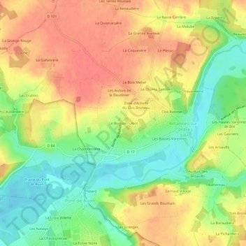
Name: Le Buisson Sabot topographic map, elevation, terrain.
Average elevation: 236 ft
Minimum elevation: 131 ft
Maximum elevation: 325 ft
Other topographic maps
Click on a map to view its topography, its elevation and its terrain.
Le Clos Bruneau
France > Centre-Val de Loire > Indre-et-Loire > Artannes-sur-Indre
Le Clos Bruneau, Artannes-sur-Indre, Tours, Indre-et-Loire, Centre-Val de Loire, France métropolitaine, 37260, France
Average elevation: 243 ft
Le Bourg
France > Centre-Val de Loire > Indre-et-Loire > Artannes-sur-Indre
Le Bourg, Artannes-sur-Indre, Tours, Indre-et-Loire, Centre-Val de Loire, France métropolitaine, 37260, France
Average elevation: 240 ft
Les Ansaults
France > Centre-Val de Loire > Indre-et-Loire > Artannes-sur-Indre
Les Ansaults, Artannes-sur-Indre, Tours, Indre-et-Loire, Centre-Val de Loire, France métropolitaine, 37260, France
Average elevation: 240 ft