
Ighrem topographic map
Interactive map
Click on the map to display elevation.
About this map
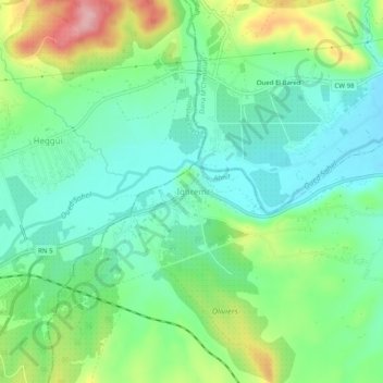
Name: Ighrem topographic map, elevation, terrain.
Location: Ighrem, Ahnif, M'Chedallah District, Bouira, 10021, Algeria (36.31806 4.16746 36.35806 4.20746)
Average elevation: 1,280 ft
Minimum elevation: 1,115 ft
Maximum elevation: 1,634 ft
Other topographic maps
Click on a map to view its topography, its elevation and its terrain.
Lalla Khedidja
Algeria > Bouira > M'Chedallah District > Saharidj
Lalla Khedidja, Saharidj, M'Chedallah District, Bouira, Algeria
Average elevation: 5,764 ft
Chorfa
Algeria > Bouira > M'Chedallah District
Chorfa, M'Chedallah District, Bouira, Algeria
Average elevation: 1,476 ft