
Manquiri topographic map
Interactive map
Click on the map to display elevation.
About this map
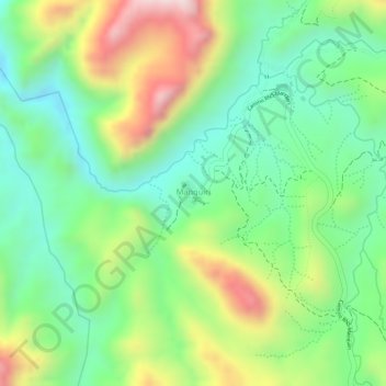
Name: Manquiri topographic map, elevation, terrain.
Location: Manquiri, Potosí, Provincia Tomás Frías, Potosí, Bolivia (-19.43029 -65.71980 -19.42817 -65.71706)
Average elevation: 11,785 ft
Minimum elevation: 11,237 ft
Maximum elevation: 12,621 ft
Other topographic maps
Click on a map to view its topography, its elevation and its terrain.
Huari Huari
Bolivia > Potosí > Provincia Tomás Frías > Potosí
Huari Huari, Potosí, Provincia Tomás Frías, Potosí, Bolivia
Average elevation: 12,963 ft
Thamari
Bolivia > Potosí > Provincia Tomás Frías > Potosí
Thamari, Potosí, Provincia Tomás Frías, Potosí, Bolivia
Average elevation: 11,588 ft