Geolocate

Uluwatu topographic map

Click on the map to display elevation.

About this map

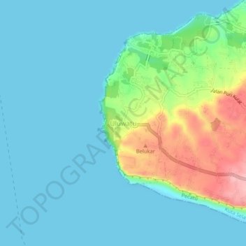
Name: Uluwatu topographic map, elevation, terrain.

Location: Uluwatu, Pecatu, Kuta Selatan, Badung, Bali, Lesser Sunda Islands, Indonesia (-8.84828 115.06800 -8.80828 115.10800)

Average elevation: 102 ft

Minimum elevation: 0 ft

Maximum elevation: 472 ft

Other topographic maps

Click on a map to view its topography, its elevation and its terrain.

Kuta Beach

Indonesia > Bali > Badung > Kuta

Average elevation: 13 ft

Legian

Indonesia > Bali > Badung > Kuta

Average elevation: 16 ft

Kerobokan Kelod

Indonesia > Bali > Badung

Average elevation: 56 ft

Padang Padang Beach

Indonesia > Bali > Badung > Pecatu

Average elevation: 115 ft

Pecatu

Indonesia > Bali > Badung

Pecatu is located in South Kuta District of Badung Regency. It is at the western end of the Bukit Peninsula in south Bali, and has a hilly topography with limestone cliffs isolating small, short beaches that have been privately developed. Nusa Dua, on the opposite side of the peninsula, is flat and is a…

Average elevation: 256 ft

Kuta

Indonesia > Bali > Badung

Average elevation: 10 ft

Jimbaran

Indonesia > Bali > Badung

Average elevation: 167 ft

Seminyak

Indonesia > Bali > Badung > Kuta

Average elevation: 23 ft

Kutuh

Indonesia > Bali > Badung

Average elevation: 344 ft

Ungasan

Indonesia > Bali > Badung

Average elevation: 387 ft

Benoa

Indonesia > Bali > Badung

Average elevation: 118 ft

Kerobokan

Indonesia > Bali > Badung

Average elevation: 102 ft

Seminyak

Indonesia > Bali > Badung > Kuta

Average elevation: 23 ft

Canggu

Indonesia > Bali > Badung

Average elevation: 82 ft

Jimbaran

Indonesia > Bali > Badung

Average elevation: 167 ft

Kerobokan

Indonesia > Bali > Badung

Average elevation: 112 ft

Kerobokan

Indonesia > Bali > Badung

Average elevation: 112 ft

Seminyak

Indonesia > Bali > Badung > Kuta

Average elevation: 30 ft

Jimbaran

Indonesia > Bali > Badung

Average elevation: 167 ft

Pantai Canggu

Indonesia > Bali > Badung > Canggu

Average elevation: 16 ft

North Kuta

Indonesia > Bali > Badung

Average elevation: 115 ft

Nyang Nyang

Indonesia > Bali > Badung > Pecatu

Average elevation: 141 ft

Legian

Indonesia > Bali > Badung > Kuta

Average elevation: 16 ft

Gear up for your next adventure:

🥤Water Filter Bottle - All‑in‑one filter bottle for safe hydration
🛡️Bear Spray Outdoor - Protection in bear country hikes
💧Water Purification System - Clean water on the trail with reliable purifiers
🌡️Portable Weather Meter - Track weather conditions on the trail
🪶Trail Camera - Capture wildlife on your hikes

As an Amazon Associate, this site earns from qualifying purchases at no extra cost to you.