
Make a donation
Gear up for your next adventure:
As an Amazon Associate, this site earns from qualifying purchases at no extra cost to you.
Haldenstein topographic map
Click on the map to display elevation.
Make a donation
Gear up for your next adventure:
As an Amazon Associate, this site earns from qualifying purchases at no extra cost to you.
Haldenstein
Before 2017, the municipality was located in the Fünf Dörfer sub-district of the Landquart district, after 2017 it was part of the Plessur Region. It is located north of Chur and on the left bank of the Rhine River. It consists of the haufendorf (an irregular, unplanned and quite closely packed village, built around a central square) village of Haldenstein (which is an elevation of 572 meters (1,877 ft)) and the hamlets of Batänja (formerly: Sewils) (which is at 1,400 meters (4,600 ft)) and Berg (which is at 1,505 meters (4,938 ft)). The municipality's boundaries are the Rhine and then up the Calanda mountain from the river to the border with the canton of St. Gallen.
Make a donation
Gear up for your next adventure:
As an Amazon Associate, this site earns from qualifying purchases at no extra cost to you.
About this map
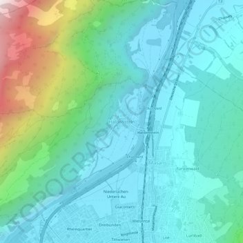
Name: Haldenstein topographic map, elevation, terrain.
Location: Haldenstein, Chur, Plessur, Grisons, 7023, Switzerland (46.85801 9.50674 46.89801 9.54674)
Average elevation: 2,710 ft
Minimum elevation: 1,752 ft
Maximum elevation: 6,509 ft
Make a donation
Gear up for your next adventure:
As an Amazon Associate, this site earns from qualifying purchases at no extra cost to you.