
Gemeinde Weißenbach am Lech topographic map
Interactive map
Click on the map to display elevation.
About this map
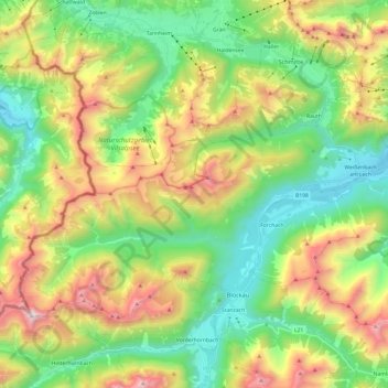
Name: Gemeinde Weißenbach am Lech topographic map, elevation, terrain.
Average elevation: 4,856 ft
Minimum elevation: 2,851 ft
Maximum elevation: 8,386 ft
Other topographic maps
Click on a map to view its topography, its elevation and its terrain.
Weißenbach am Lech
Österreich > Tirol > Bezirk Reutte > Gemeinde Weißenbach am Lech > Weißenbach am Lech
Weißenbach am Lech, Gemeinde Weißenbach am Lech, Bezirk Reutte, Tirol, 6671, Österreich
Average elevation: 3,435 ft