Geolocate

Casper topographic map

Click on the map to display elevation.

About this map

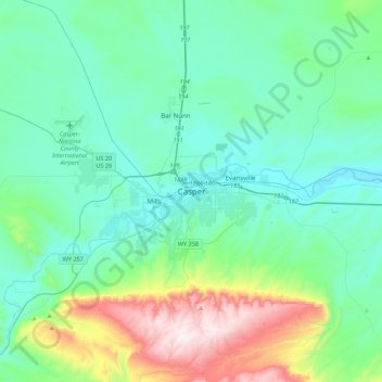
Name: Casper topographic map, elevation, terrain.

Location: Casper, Natrona County, Wyoming, 82601, United States (42.69012 -106.48514 43.01012 -106.16514)

Average elevation: 5,666 ft

Minimum elevation: 5,036 ft

Maximum elevation: 8,179 ft

Natrona County trails, hiking, mountain biking, running and outdoor activities

Gear up for your next adventure:

🌡️Handheld Weather Meters - Measure wind, temp, and pressure for safe mountain travel
🔭Stargazing Telescopes - Perfect for camping in low-light pollution areas shown on maps
Backpacking Tent - Lightweight and durable tent for multi‑day hikes
Camping Coffee Makers - Enjoy premium coffee at the summit or campsite
🧭Pro Hiking Compasses - High-accuracy liquid-filled compasses for topographic orientation

As an Amazon Associate, this site earns from qualifying purchases at no extra cost to you.