
Make a donation
Gear up for your next adventure:
As an Amazon Associate, this site earns from qualifying purchases at no extra cost to you.
Mulabagilu topographic map
Click on the map to display elevation.
Make a donation
Gear up for your next adventure:
As an Amazon Associate, this site earns from qualifying purchases at no extra cost to you.
Mulabagilu
Mulabagilu is located at 13°10′N 78°24′E / 13.17°N 78.4°E / 13.17; 78.4. It has an average elevation of 827 metres (2,713 feet).
Make a donation
Gear up for your next adventure:
As an Amazon Associate, this site earns from qualifying purchases at no extra cost to you.
About this map
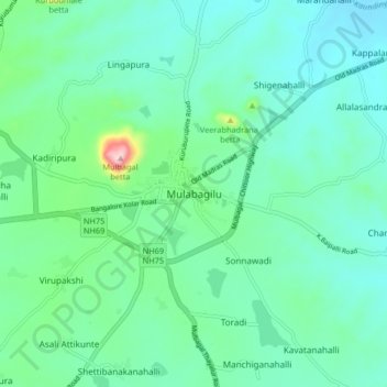
Name: Mulabagilu topographic map, elevation, terrain.
Location: Mulabagilu, Mulubagilu taluk, Kolar, Karnataka, 563131, India (13.12260 78.35590 13.20260 78.43590)
Average elevation: 2,690 ft
Minimum elevation: 2,484 ft
Maximum elevation: 3,579 ft
Make a donation
Gear up for your next adventure:
As an Amazon Associate, this site earns from qualifying purchases at no extra cost to you.