
Santana topographic map
Interactive map
Click on the map to display elevation.
About this map
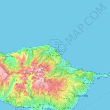
Name: Santana topographic map, elevation, terrain.
Location: Santana, Madère, 9230-121, Portugal (32.64491 -17.04130 32.96491 -16.72130)
Average elevation: 873 ft
Minimum elevation: 0 ft
Maximum elevation: 6,020 ft
Other topographic maps
Click on a map to view its topography, its elevation and its terrain.
Pico Ruivo
Pico Ruivo, Santana, Madère, 9030-311, Portugal
Average elevation: 4,593 ft
São Roque do Faial
São Roque do Faial, Santana, Madère, Portugal
Average elevation: 2,073 ft
Achada do Teixeira
Achada do Teixeira, Estrada Regional 218, Ilha, Santana, Madère, 9230-108, Portugal
Average elevation: 4,147 ft