
Make a donation
Gear up for your next adventure:
As an Amazon Associate, this site earns from qualifying purchases at no extra cost to you.
Leckford topographic map
Click on the map to display elevation.
Make a donation
Gear up for your next adventure:
As an Amazon Associate, this site earns from qualifying purchases at no extra cost to you.
About this map
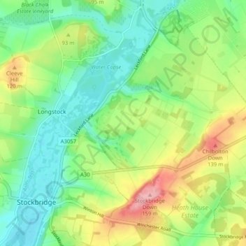
Name: Leckford topographic map, elevation, terrain.
Location: Leckford, Test Valley, Hampshire, England, United Kingdom (51.11069 -1.48344 51.14905 -1.40485)
Average elevation: 249 ft
Minimum elevation: 98 ft
Maximum elevation: 518 ft
Make a donation
Gear up for your next adventure:
As an Amazon Associate, this site earns from qualifying purchases at no extra cost to you.
Other topographic maps
Click on a map to view its topography, its elevation and its terrain.
Make a donation
Gear up for your next adventure:
As an Amazon Associate, this site earns from qualifying purchases at no extra cost to you.
Withering Corner
United Kingdom > England > Hampshire > Test Valley > Ashley
Average elevation: 394 ft
News Wood
United Kingdom > England > Hampshire > Test Valley > King's Somborne
Average elevation: 305 ft
Make a donation
Gear up for your next adventure:
As an Amazon Associate, this site earns from qualifying purchases at no extra cost to you.
Bath Meadows
United Kingdom > England > Hampshire > Test Valley > Wellow > East Wellow
Average elevation: 98 ft
Bitterne Grove
United Kingdom > England > Hampshire > Test Valley > Mottisfont > Dunbridge
Average elevation: 128 ft
Winton Hill
United Kingdom > England > Hampshire > Test Valley > Stockbridge
Average elevation: 240 ft
Make a donation
Gear up for your next adventure:
As an Amazon Associate, this site earns from qualifying purchases at no extra cost to you.
Make a donation
Gear up for your next adventure:
As an Amazon Associate, this site earns from qualifying purchases at no extra cost to you.
Make a donation
Gear up for your next adventure:
As an Amazon Associate, this site earns from qualifying purchases at no extra cost to you.
Canada Common
United Kingdom > England > Hampshire > Test Valley > Wellow > Canada
Average elevation: 128 ft
Make a donation
Gear up for your next adventure:
As an Amazon Associate, this site earns from qualifying purchases at no extra cost to you.
Make a donation
Gear up for your next adventure:
As an Amazon Associate, this site earns from qualifying purchases at no extra cost to you.
Charlton Down
United Kingdom > England > Hampshire > Test Valley > Wildhern > Charlton Down
Average elevation: 364 ft
Make a donation
Gear up for your next adventure:
As an Amazon Associate, this site earns from qualifying purchases at no extra cost to you.
The Bog
United Kingdom > England > Hampshire > Test Valley > Braishfield > Crookhill
Average elevation: 128 ft
Rockmoor Pond
United Kingdom > England > Hampshire > Test Valley > Littledown
Average elevation: 682 ft
Make a donation
Gear up for your next adventure:
As an Amazon Associate, this site earns from qualifying purchases at no extra cost to you.
Make a donation
Gear up for your next adventure:
As an Amazon Associate, this site earns from qualifying purchases at no extra cost to you.