
Thank you for supporting this site ❤️
Make a donation
Make a donation
Gear up for your next adventure:
As an Amazon Associate, this site earns from qualifying purchases at no extra cost to you.
Alamor topographic map
Click on the map to display elevation.
Thank you for supporting this site ❤️
Make a donation
Make a donation
Gear up for your next adventure:
As an Amazon Associate, this site earns from qualifying purchases at no extra cost to you.
About this map
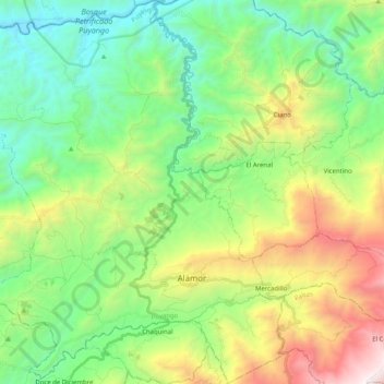
Name: Alamor topographic map, elevation, terrain.
Location: Alamor, Puyango, Loja, 110406, Ecuador (-4.07385 -80.16152 -3.87209 -79.97051)
Average elevation: 3,189 ft
Minimum elevation: 876 ft
Maximum elevation: 8,117 ft
Thank you for supporting this site ❤️
Make a donation
Make a donation
Gear up for your next adventure:
As an Amazon Associate, this site earns from qualifying purchases at no extra cost to you.