
Make a donation
Gear up for your next adventure:
As an Amazon Associate, this site earns from qualifying purchases at no extra cost to you.
Altos topographic map
Click on the map to display elevation.
Make a donation
Gear up for your next adventure:
As an Amazon Associate, this site earns from qualifying purchases at no extra cost to you.
Altos
It is also called “Altos de Ybypytaré”, which in Guaraní means “path of the wind”, previously called “San Lorenzo de la Cordillera de los Altos”, one of the oldest cities of Paraguay. It is known as the “Terrace of the country” because of its high altitude.
Make a donation
Gear up for your next adventure:
As an Amazon Associate, this site earns from qualifying purchases at no extra cost to you.
About this map
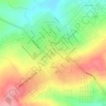
Name: Altos topographic map, elevation, terrain.
Location: Altos, Cordillera Department, Región Oriental, Paraguay (-25.27515 -57.25974 -25.25350 -57.24079)
Average elevation: 682 ft
Minimum elevation: 476 ft
Maximum elevation: 883 ft
Make a donation
Gear up for your next adventure:
As an Amazon Associate, this site earns from qualifying purchases at no extra cost to you.
Other topographic maps
Click on a map to view its topography, its elevation and its terrain.
Make a donation
Gear up for your next adventure:
As an Amazon Associate, this site earns from qualifying purchases at no extra cost to you.