
Fintown topographic map
Interactive map
Click on the map to display elevation.
About this map
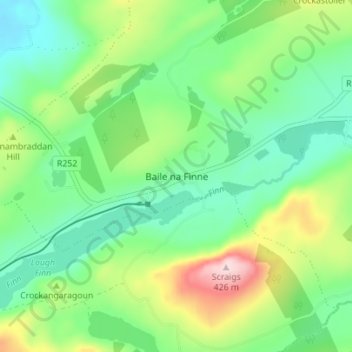
Name: Fintown topographic map, elevation, terrain.
Location: Fintown, Glenties Municipal District, County Donegal, Ireland (54.85056 -8.13333 54.89056 -8.09333)
Average elevation: 614 ft
Minimum elevation: 276 ft
Maximum elevation: 1,365 ft
Other topographic maps
Click on a map to view its topography, its elevation and its terrain.
Raphoe
Raphoe, Lifford-Stranorlar Municipal District, County Donegal, Ireland
Average elevation: 259 ft
Moneydarragh
Moneydarragh, Gleneely ED, Inishowen Municipal District, County Donegal, Ulster, Ireland
Average elevation: 495 ft
Dunlewy ED
Dunlewy ED, Glenties Municipal District, County Donegal, Ulster, Ireland
Average elevation: 728 ft
Letterkenny
Letterkenny, County Donegal, Ulster, Ireland
Average elevation: 302 ft
Creeslough
Creeslough, Creeslough ED, Glenties Municipal District, County Donegal, Ulster, F92 W803, Ireland
Average elevation: 141 ft
Dunfanaghy
Dunfanaghy, Dunfanaghy Electoral Division, Glenties Municipal District, County Donegal, Ulster, F92 H0CY, Ireland
Average elevation: 69 ft
Cashel
Cashel, Donegal Municipal District, County Donegal, Ireland
Average elevation: 354 ft
Greenfort Island
Greenfort Island, Greenfort ED, County Donegal, Ireland
Average elevation: 75 ft
Moyle
Ireland > County Donegal > Letterkenny
Moyle, Ballyarr ED, Letterkenny, County Donegal, Ireland
Average elevation: 180 ft
Buncrana
Ireland > County Donegal > Buncrana
Buncrana, Inishowen Municipal District, County Donegal, F93 C9X6, Ireland
Average elevation: 207 ft