
Make a donation
Gear up for your next adventure:
As an Amazon Associate, this site earns from qualifying purchases at no extra cost to you.
Vinhedo topographic map
Click on the map to display elevation.
Make a donation
Gear up for your next adventure:
As an Amazon Associate, this site earns from qualifying purchases at no extra cost to you.
Vinhedo
Vinhedo (Portuguese pronunciation: [viˈɲedu]) is a municipality in the state of São Paulo in Brazil. It is part of the Metropolitan Region of Campinas. The population in 2020 was 80,111 and its area is 81.60 km2 (31.51 sq mi). It has a population density of 981 inhabitants per square kilometer. The elevation is 777 m (2,549 ft). Vinhedo is 96% urbanized and It was founded in 1949.
Make a donation
Gear up for your next adventure:
As an Amazon Associate, this site earns from qualifying purchases at no extra cost to you.
About this map
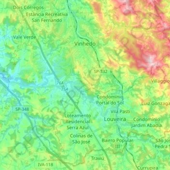
Name: Vinhedo topographic map, elevation, terrain.
Average elevation: 2,411 ft
Minimum elevation: 2,044 ft
Maximum elevation: 3,219 ft
Make a donation
Gear up for your next adventure:
As an Amazon Associate, this site earns from qualifying purchases at no extra cost to you.
Other topographic maps
Click on a map to view its topography, its elevation and its terrain.
João Aranha
Brazil > São Paulo > Região Metropolitana de Campinas > Paulínia
Average elevation: 1,913 ft