
Les Poisats topographic map
Interactive map
Click on the map to display elevation.
About this map
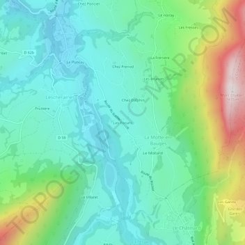
Name: Les Poisats topographic map, elevation, terrain.
Average elevation: 2,644 ft
Minimum elevation: 1,877 ft
Maximum elevation: 4,787 ft
Other topographic maps
Click on a map to view its topography, its elevation and its terrain.
Le noiray
France > Auvergne-Rhône-Alpes > Savoie > La Motte-en-Bauges
Le noiray, La Motte-en-Bauges, Chambéry, Savoie, Auvergne-Rhône-Alpes, France métropolitaine, 73340, France
Average elevation: 2,877 ft