
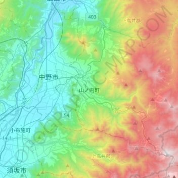
Yamanouchi topographic map
Interactive map
Click on the map to display elevation.
About this map
Name: Yamanouchi topographic map, elevation, terrain.
Location: Yamanouchi, Shimotakai County, Nagano Prefecture, Japan (36.66571 138.38338 36.82465 138.64215)
Average elevation: 3,091 ft
Minimum elevation: 1,001 ft
Maximum elevation: 7,556 ft
Shimotakai District, in northern mountainous Nagano Prefecture, comprises Yamanouchi town, Kijimadaira Village, and Nozawaonsen Village. Yamanouchi is the largest of these. More than 90% of Yamanouchi is covered by mountains and forests. The town measures approximately 39 kilometers east-west and 12 kilometers north-south (266 square kilometers), and has an elevation ranging from 424 meters to 2341 meters. The surrounding area is known for its forest therapy.
Other topographic maps
Click on a map to view its topography, its elevation and its terrain.
Nozawaonsen
Nozawaonsen, Shimotakai County, Nagano Prefecture, Chubu Region, 389-2502, Japan
Average elevation: 2,329 ft
Biwa Lake
Japan > Shimotakai County > Yamanouchi
Biwa Lake, Yamanouchi, Shimotakai County, Nagano Prefecture, Japan
Average elevation: 4,488 ft