
Rasdorf topographic map
Interactive map
Click on the map to display elevation.
About this map
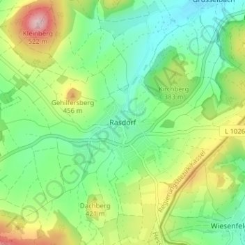
Name: Rasdorf topographic map, elevation, terrain.
Location: Rasdorf, Landkreis Fulda, Hesse, 36169, Germany (50.70033 9.87773 50.74033 9.91773)
Average elevation: 1,188 ft
Minimum elevation: 922 ft
Maximum elevation: 1,690 ft
Other topographic maps
Click on a map to view its topography, its elevation and its terrain.
Ehrenberg
Germany > Hesse > Landkreis Fulda
Ehrenberg, Landkreis Fulda, Hesse, Germany
Average elevation: 2,323 ft
Fulda
Germany > Hesse > Landkreis Fulda
Fulda, Landkreis Fulda, Hesse, Germany
Average elevation: 1,063 ft