
Putte topographic map
Interactive map
Click on the map to display elevation.
About this map
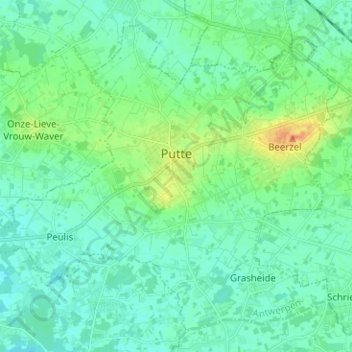
Name: Putte topographic map, elevation, terrain.
Location: Putte, Mechelen, Antwerp, Flanders, 2580, Belgium (51.01721 4.56351 51.08687 4.68925)
Average elevation: 39 ft
Minimum elevation: 10 ft
Maximum elevation: 138 ft
With an altitude of 51.60 metres (169.3 ft), the Beerzelberg in Beerzel is the highest point of the Antwerp province.
Other topographic maps
Click on a map to view its topography, its elevation and its terrain.
Heist-op-den-Berg
Belgium > Antwerp > Mechelen > Heist-op-den-Berg
Heist-op-den-Berg, Mechelen, Antwerp, Flanders, 2220, Belgium
Average elevation: 39 ft
Sint-Katelijne-Waver
Belgium > Antwerp > Mechelen > Sint-Katelijne-Waver
Sint-Katelijne-Waver, Mechelen, Antwerp, Flanders, 2860, Belgium
Average elevation: 20 ft