
Fradelos topographic map
Interactive map
Click on the map to display elevation.
About this map
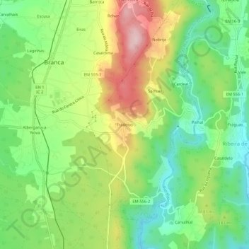
Name: Fradelos topographic map, elevation, terrain.
Average elevation: 522 ft
Minimum elevation: 157 ft
Maximum elevation: 1,056 ft
Other topographic maps
Click on a map to view its topography, its elevation and its terrain.
Cristelo
Portugal > Aveiro > Albergaria-a-Velha > Branca
Cristelo, Branca, Albergaria-a-Velha, Aveiro, 3850-516, Portugal
Average elevation: 305 ft
Mundo Novo
Portugal > Aveiro > Albergaria-a-Velha > Branca
Mundo Novo, Branca, Albergaria-a-Velha, Aveiro, 3850-501, Portugal
Average elevation: 535 ft