
Agrihan topographic map
Interactive map
Click on the map to display elevation.
About this map
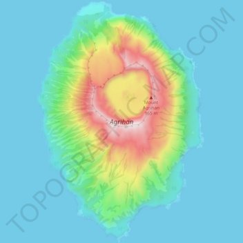
Name: Agrihan topographic map, elevation, terrain.
Average elevation: 584 ft
Minimum elevation: -3 ft
Maximum elevation: 3,127 ft
Other topographic maps
Click on a map to view its topography, its elevation and its terrain.
Kagman
United States of America > Northern Mariana Islands > Kagman
Kagman, Saipan Municipality, Northern Mariana Islands, United States of America
Average elevation: 105 ft
Songsong
United States of America > Northern Mariana Islands > Songsong
Songsong, Rota Municipality, Northern Mariana Islands, United States of America
Average elevation: 85 ft