
Communauté de communes Haut-Jura Saint-Claude topographic map
Interactive map
Click on the map to display elevation.
About this map
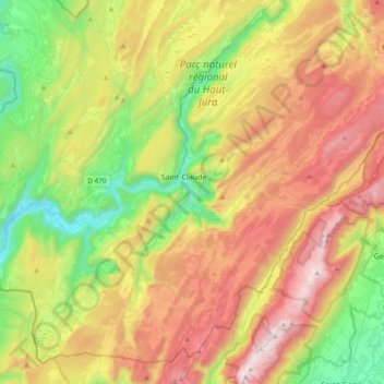
Name: Communauté de communes Haut-Jura Saint-Claude topographic map, elevation, terrain.
Average elevation: 2,989 ft
Minimum elevation: 1,033 ft
Maximum elevation: 5,607 ft
Other topographic maps
Click on a map to view its topography, its elevation and its terrain.
Valfin-lès-Saint-Claude
France > Bourgogne-Franche-Comté > Saint-Claude
Valfin-lès-Saint-Claude, Saint-Claude, Jura, Bourgogne-Franche-Comté, France métropolitaine, 39200, France
Average elevation: 2,546 ft