
Carmen del Paraná topographic map
Interactive map
Click on the map to display elevation.
About this map
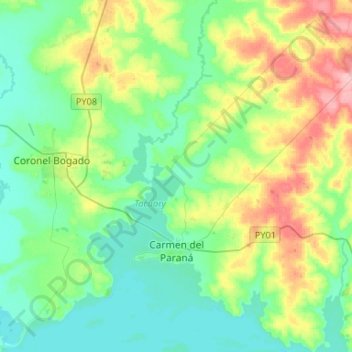
Name: Carmen del Paraná topographic map, elevation, terrain.
Location: Carmen del Paraná, Itapúa, Región Oriental, Paraguay (-27.28842 -56.18010 -27.05386 -55.97810)
Average elevation: 354 ft
Minimum elevation: 236 ft
Maximum elevation: 653 ft
Other topographic maps
Click on a map to view its topography, its elevation and its terrain.
San Martín
Paraguay > Itapúa > Carmen del Paraná
San Martín, Carmen del Paraná, Itapúa, Región Oriental, Paraguay
Average elevation: 407 ft