
Waldshut-Tiengen topographic map
Interactive map
Click on the map to display elevation.
About this map
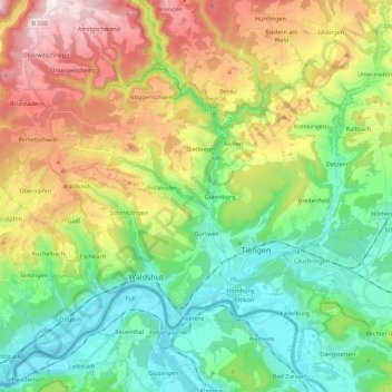
Name: Waldshut-Tiengen topographic map, elevation, terrain.
Average elevation: 1,814 ft
Minimum elevation: 988 ft
Maximum elevation: 3,304 ft
Other topographic maps
Click on a map to view its topography, its elevation and its terrain.
Bonndorf im Schwarzwald
Germany > Baden-Württemberg > Landkreis Waldshut
Bonndorf im Schwarzwald, Verwaltungsgemeinschaft Bonndorf im Schwarzwald, Landkreis Waldshut, Baden-Württemberg, 79848, Germany
Average elevation: 2,615 ft