
Civitella di Romagna topographic map
Interactive map
Click on the map to display elevation.
About this map
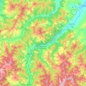
Name: Civitella di Romagna topographic map, elevation, terrain.
Average elevation: 1,398 ft
Minimum elevation: 272 ft
Maximum elevation: 2,887 ft
Le centre habité est situé à environ 30 km au Sud du chef-lieu Forlì, à 238 mètres d’altitude sur la route provinciale S310 le long du fleuve Bidente et son affluent le Ronco. Les communes les plus proches sont. Meldola 21 km, Galeata 2 km, Santa Sofia 10 km.