
Yamoussoukro topographic map
Interactive map
Click on the map to display elevation.
About this map
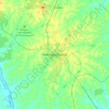
Name: Yamoussoukro topographic map, elevation, terrain.
Location: Yamoussoukro, Côte d'Ivoire (6.66001 -5.43760 6.98001 -5.11760)
Average elevation: 650 ft
Minimum elevation: 466 ft
Maximum elevation: 1,237 ft
Other topographic maps
Click on a map to view its topography, its elevation and its terrain.