Geolocate

Prato topographic map

Click on the map to display elevation.

About this map

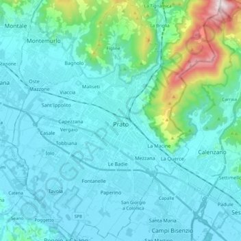
Name: Prato topographic map, elevation, terrain.

Location: Prato, Tuscany, 59100, Italy (43.81576 11.01317 43.94948 11.16961)

Average elevation: 486 ft

Minimum elevation: 102 ft

Maximum elevation: 3,005 ft

Other topographic maps

Click on a map to view its topography, its elevation and its terrain.

Migliana

Italy > Tuscany > Prato

Average elevation: 1,932 ft

Gear up for your next adventure:

🧭Pro Hiking Compasses - High-accuracy liquid-filled compasses for topographic orientation
🦟Ultrasonic Repellers - Create a bug-free zone at your camp or rest stop
💧Water Filtration Bottles - Safely drink from streams and lakes while exploring
🌡️Handheld Weather Meters - Measure wind, temp, and pressure for safe mountain travel
🚪Portable Camp Chair - Foldable chair for comfort at camp

As an Amazon Associate, this site earns from qualifying purchases at no extra cost to you.