Geolocate

衢山镇 topographic map

Interactive map

Click on the map to display elevation.

About this map

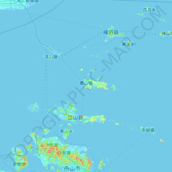
Name: 衢山镇 topographic map, elevation, terrain.

Location: 衢山镇, 舟山群岛新区, 岱山县, 舟山市, 浙江省, 中国 (30.23626 122.01141 30.62757 123.09563)

Average elevation: 16 ft

Minimum elevation: -16 ft

Maximum elevation: 1,506 ft

Other topographic maps

Click on a map to view its topography, its elevation and its terrain.

大蛟山岛

中国 > 浙江省 > 岱山县

大蛟山岛, 舟山群岛新区, 岱山县, 舟山市, 浙江省, 中国

Average elevation: 10 ft

小长涂山

中国 > 浙江省 > 岱山县

小长涂山, 岱山县, 舟山市, 浙江省, 中国

Average elevation: 72 ft

官山

中国 > 浙江省 > 岱山县

官山, 舟山群岛新区, 岱山县, 舟山市, 浙江省, 中国

Average elevation: 52 ft

衢山岛

中国 > 浙江省 > 岱山县

衢山岛, 岱山县, 舟山市, 浙江省, 中国

Average elevation: 10 ft

岱山岛

中国 > 浙江省 > 岱山县

岱山岛, 岱山县, 舟山市, 浙江省, 中国

Average elevation: 33 ft

小长涂山

中国 > 浙江省 > 岱山县

小长涂山, 岱山县, 舟山市, 浙江省, 中国

Average elevation: 30 ft

秀山岛

中国 > 浙江省 > 岱山县

秀山岛, 岱山县, 舟山市, 浙江省, 316261, 中国

Average elevation: 46 ft

大长涂山

中国 > 浙江省 > 岱山县

大长涂山, 岱山县, 舟山市, 浙江省, 中国

Average elevation: 30 ft