
Hen Island topographic map
Interactive map
Click on the map to display elevation.
About this map
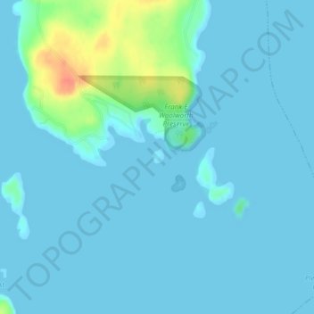
Name: Hen Island topographic map, elevation, terrain.
Location: Hen Island, Washington County, Maine, USA (44.51956 -67.78795 44.52099 -67.78635)
Average elevation: 20 ft
Minimum elevation: 0 ft
Maximum elevation: 154 ft
Other topographic maps
Click on a map to view its topography, its elevation and its terrain.
Acadia National Park
USA > Maine > Otter Creek
Acadia National Park, Schiff Path, Otter Creek, Hancock County, Maine, 04609, USA
Average elevation: 30 ft
Cataract Dam
Cataract Dam, Saco, York County, Maine, 04072, USA
Average elevation: 72 ft
Cliff Island
USA > Maine > Cliff Island
Cliff Island, Cumberland County, Maine, 04019, USA
Average elevation: 3 ft
Flagstaff Hut
Flagstaff Hut, Maine Huts Trail, Somerset County, Maine, USA
Average elevation: 1,152 ft
Green Islands
Green Islands, Southport, Lincoln County, Maine, USA
Average elevation: 13 ft
Saddleback Mountain
Saddleback Mountain, Aroostook County, Maine, USA
Average elevation: 1,178 ft
Round Mountain
USA > Maine > Alder Stream Township
Round Mountain, Alder Stream Township, Franklin County, Maine, USA
Average elevation: 2,205 ft