
Red Branch topographic map
Interactive map
Click on the map to display elevation.
About this map
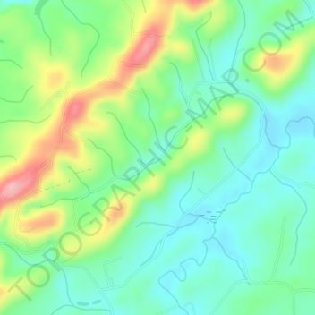
Name: Red Branch topographic map, elevation, terrain.
Location: Red Branch, Monroe County, Tennessee, USA (35.58090 -84.36006 35.58217 -84.35819)
Average elevation: 1,014 ft
Minimum elevation: 860 ft
Maximum elevation: 1,319 ft
Other topographic maps
Click on a map to view its topography, its elevation and its terrain.
Hill Country
USA > Tennessee > Hill Country
Hill Country, Sullivan County, Tennessee, 37621, USA
Average elevation: 1,798 ft
Clarksville
USA > Tennessee > Clarksville
Clarksville, Montgomery County, Tennessee, USA
Average elevation: 509 ft
Great Smoky Mountains National Park
Great Smoky Mountains National Park, Little River Trail, Elkmont, Sevier County, Tennessee, USA
Average elevation: 2,510 ft
Mount Harrison
Mount Harrison, Sevier County, Tennessee, USA
Average elevation: 3,041 ft
Wellington Park
USA > Tennessee > Wellington Park
Wellington Park, Washington County, Tennessee, 37604, USA
Average elevation: 1,795 ft