
Ampsin topographic map
Interactive map
Click on the map to display elevation.
About this map
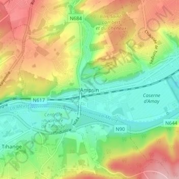
Name: Ampsin topographic map, elevation, terrain.
Location: Ampsin, Amay, Huy, Liège, Wallonie, 4540, Belgique (50.52024 5.26674 50.56024 5.30674)
Average elevation: 413 ft
Minimum elevation: 177 ft
Maximum elevation: 751 ft
Other topographic maps
Click on a map to view its topography, its elevation and its terrain.
Château de Jehay
Château de Jehay, 1, Rue du Parc, Amay, Huy, Liège, Wallonie, 4540, Belgique
Average elevation: 591 ft