
Mainaschaff topographic map
Interactive map
Click on the map to display elevation.
About this map
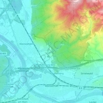
Name: Mainaschaff topographic map, elevation, terrain.
Location: Mainaschaff, Landkreis Aschaffenburg, Bayern, 63814, Deutschland (49.97312 9.06484 50.02655 9.11246)
Average elevation: 509 ft
Minimum elevation: 331 ft
Maximum elevation: 1,145 ft
Die Gemeinde liegt westlich angrenzend an die Stadt Aschaffenburg am rechten Mainufer nahe an der Landesgrenze zu Hessen. Der topographisch höchste Punkt der Gemeindegemarkung befindet sich ca. 700 m südwestlich von Sternberg mit 330 m ü. NHN (Lage)50.026489.10207, der niedrigste liegt im Main auf 108,5 m ü. NHN (Lage)49.988319.0649.
Other topographic maps
Click on a map to view its topography, its elevation and its terrain.
Hösbach
Deutschland > Bayern > Landkreis Aschaffenburg
Hösbach, Landkreis Aschaffenburg, Bayern, 63768, Deutschland
Average elevation: 732 ft