
Oba Mahallesi topographic map
Interactive map
Click on the map to display elevation.
About this map
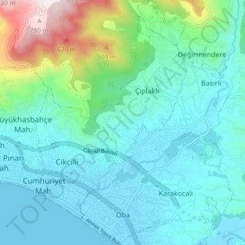
Name: Oba Mahallesi topographic map, elevation, terrain.
Location: Oba Mahallesi, Alanya, Antalya, Mediterranean Region, Turkey (36.52970 32.03221 36.58205 32.07319)
Average elevation: 502 ft
Minimum elevation: -10 ft
Maximum elevation: 2,644 ft
Other topographic maps
Click on a map to view its topography, its elevation and its terrain.
Bayırkozağacı
Bayırkozağacı, Alanya, Antalya, Mediterranean Region, Turkey
Average elevation: 3,192 ft
Tophane Mahallesi
Tophane Mahallesi, Alanya, Antalya, Mediterranean Region, Turkey
Average elevation: 56 ft