
Alexandria topographic map
Interactive map
Click on the map to display elevation.
About this map
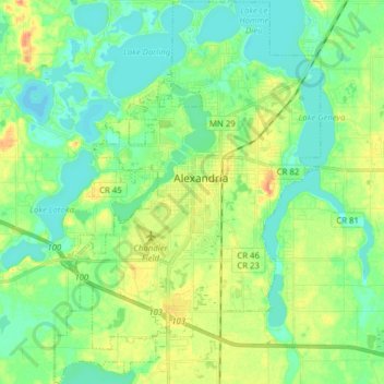
Name: Alexandria topographic map, elevation, terrain.
Location: Alexandria, Douglas County, Minnesota, 56308, United States (45.82502 -95.43445 45.93395 -95.32556)
Average elevation: 1,398 ft
Minimum elevation: 1,352 ft
Maximum elevation: 1,480 ft
Other topographic maps
Click on a map to view its topography, its elevation and its terrain.
Osakis
United States > Minnesota > Douglas County
Osakis, Douglas County, Minnesota, United States
Average elevation: 1,339 ft
Alexandria
United States > Minnesota > Douglas County > Alexandria > Alexandria
Alexandria, Douglas County, Minnesota, 56308, United States
Average elevation: 1,398 ft