Geolocate

Osakis topographic map

Click on the map to display elevation.

About this map

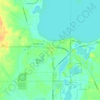
Name: Osakis topographic map, elevation, terrain.

Location: Osakis, Douglas County, Minnesota, United States (45.85510 -95.17170 45.87708 -95.11164)

Average elevation: 1,339 ft

Minimum elevation: 1,306 ft

Maximum elevation: 1,411 ft

Douglas County trails, hiking, mountain biking, running and outdoor activities

Other topographic maps

Click on a map to view its topography, its elevation and its terrain.

Lake Agnes

United States > Minnesota > Douglas County > Alexandria

Average elevation: 1,401 ft

Alexandria

United States > Minnesota > Douglas County > Alexandria > Alexandria

Average elevation: 1,398 ft

Gear up for your next adventure:

🧺Microfiber Travel Towels - Compact and fast-drying towels for trail use
🗺️NatGeo Topo Maps - High-quality waterproof printed topographic maps of US Parks
🧥Men's Rain Shells - Premium waterproof and breathable jackets for mountain weather
🌡️Handheld Weather Meters - Measure wind, temp, and pressure for safe mountain travel
🎒Gear Packing Cubes - Organize your backpack efficiently

As an Amazon Associate, this site earns from qualifying purchases at no extra cost to you.