
Buzançais topographic map
Interactive map
Click on the map to display elevation.
About this map
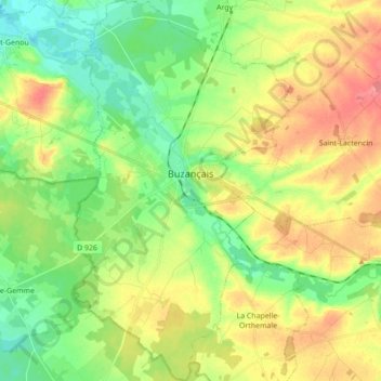
Name: Buzançais topographic map, elevation, terrain.
Average elevation: 427 ft
Minimum elevation: 318 ft
Maximum elevation: 574 ft
Other topographic maps
Click on a map to view its topography, its elevation and its terrain.
²Le Grand Champ
France > Centre-Val de Loire > Indre > Lourouer-Saint-Laurent
Average elevation: 679 ft
Les Illions
France > Centre-Val de Loire > Indre > Buzançais > Saint-Étienne
Average elevation: 384 ft