
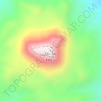
Santiago Peak topographic map
Interactive map
Click on the map to display elevation.
About this map
Name: Santiago Peak topographic map, elevation, terrain.
Location: Santiago Peak, Brewster County, Texas, United States (29.83513 -103.41634 29.83523 -103.41624)
Average elevation: 5,003 ft
Minimum elevation: 3,901 ft
Maximum elevation: 6,526 ft
Other topographic maps
Click on a map to view its topography, its elevation and its terrain.
Alpine
United States > Texas > Brewster County
Alpine, Brewster County, Texas, United States
Average elevation: 4,505 ft
Alpine
United States > Texas > Brewster County
Alpine, Brewster County, Texas, United States
Average elevation: 4,505 ft
Terlingua
United States > Texas > Brewster County
Terlingua, Brewster County, Texas, United States
Average elevation: 2,861 ft
Big Bend National Park
United States > Texas > Brewster County
Big Bend National Park, Brewster County, Texas, 79834, United States
Average elevation: 3,064 ft
Big Bend National Park
United States > Texas > Brewster County
Big Bend National Park, Brewster County, Texas, 79834, United States
Average elevation: 3,064 ft
Horseshoe Mesa
United States > Texas > Brewster County
Horseshoe Mesa, Brewster County, Texas, United States
Average elevation: 3,314 ft
Marathon
United States > Texas > Brewster County
Marathon, Brewster County, Texas, 79842, United States
Average elevation: 4,081 ft
Cathedral Mountain
United States > Texas > Brewster County
Cathedral Mountain, Brewster County, Texas, United States
Average elevation: 5,338 ft
Dagger Mountain
United States > Texas > Brewster County
Dagger Mountain, Brewster County, Texas, United States
Average elevation: 3,504 ft
Lajitas
United States > Texas > Brewster County
Lajitas, Brewster County, Texas, United States
Average elevation: 2,477 ft
Emory Peak
United States > Texas > Brewster County
Emory Peak, Brewster County, Texas, United States
Average elevation: 6,762 ft