
Make a donation
Gear up for your next adventure:
As an Amazon Associate, this site earns from qualifying purchases at no extra cost to you.
Orán topographic map
Click on the map to display elevation.
Make a donation
Gear up for your next adventure:
As an Amazon Associate, this site earns from qualifying purchases at no extra cost to you.
About this map
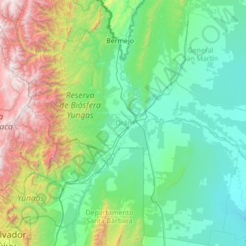
Name: Orán topographic map, elevation, terrain.
Location: Orán, Salta, Argentina (-24.22350 -65.07479 -22.44161 -63.40210)
Average elevation: 3,255 ft
Minimum elevation: 728 ft
Maximum elevation: 16,719 ft
Make a donation
Gear up for your next adventure:
As an Amazon Associate, this site earns from qualifying purchases at no extra cost to you.
Other topographic maps
Click on a map to view its topography, its elevation and its terrain.
Nevado de Cachi
Nevado de Cachi is the name given to a large complex of mountains that lies in Salta Province, Argentina. This complex counts several summits, the highest being 6,380m and it is called Cumbre Libertador. This summit was climbed for the first time in 1950. The mountains overlook Cachi, a traditional village of…
Average elevation: 19,357 ft