
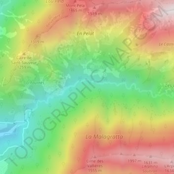
Vallon de Planquette topographic map
Interactive map
Click on the map to display elevation.
About this map
Name: Vallon de Planquette topographic map, elevation, terrain.
Average elevation: 3,570 ft
Minimum elevation: 1,801 ft
Maximum elevation: 5,531 ft
Other topographic maps
Click on a map to view its topography, its elevation and its terrain.
Ferraya
France > Provence-Alpes-Côte d'Azur > Alpes-Maritimes > La Bollène-Vésubie
Ferraya, La Bollène-Vésubie, Nice, Alpes-Maritimes, Provence-Alpes-Côte d'Azur, France métropolitaine, 06450, France
Average elevation: 2,621 ft
Col de Turini
France > Provence-Alpes-Côte d'Azur > Alpes-Maritimes > La Bollène-Vésubie > Col de Turini
Col de Turini, La Bollène-Vésubie, Nice, Alpes-Maritimes, Provence-Alpes-Côte d'Azur, France métropolitaine, 06450, France
Average elevation: 4,790 ft