
Make a donation
Gear up for your next adventure:
As an Amazon Associate, this site earns from qualifying purchases at no extra cost to you.
Río Negro Province topographic map
Click on the map to display elevation.
Make a donation
Gear up for your next adventure:
As an Amazon Associate, this site earns from qualifying purchases at no extra cost to you.
Río Negro Province
The climate of the province is temperate at low elevations, and very cold in the higher Andean peaks.
Make a donation
Gear up for your next adventure:
As an Amazon Associate, this site earns from qualifying purchases at no extra cost to you.
About this map
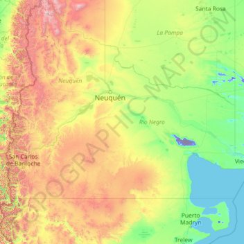
Name: Río Negro Province topographic map, elevation, terrain.
Location: Río Negro Province, Argentina (-41.99209 -71.91207 -37.57478 -62.78956)
Average elevation: 2,037 ft
Minimum elevation: -233 ft
Maximum elevation: 14,780 ft
Make a donation
Gear up for your next adventure:
As an Amazon Associate, this site earns from qualifying purchases at no extra cost to you.
Other topographic maps
Click on a map to view its topography, its elevation and its terrain.
Make a donation
Gear up for your next adventure:
As an Amazon Associate, this site earns from qualifying purchases at no extra cost to you.
San Rafael
Argentina > Mendoza > Distrito Ciudad de San Rafael > San Rafael
Average elevation: 2,264 ft
Make a donation
Gear up for your next adventure:
As an Amazon Associate, this site earns from qualifying purchases at no extra cost to you.