
Lytton topographic map
Interactive map
Click on the map to display elevation.
About this map
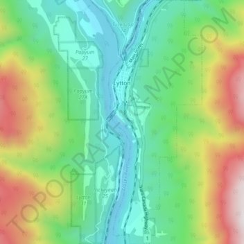
Name: Lytton topographic map, elevation, terrain.
Average elevation: 1,716 ft
Minimum elevation: 413 ft
Maximum elevation: 4,459 ft
Lytton has set Canadian records for highest temperature and experiences either a dry-summer warm-summer humid continental climate (Köppen climate classification: Dsb bordering Dsa), or a warm-summer mediterranean climate (Köppen climate classification: Csb bordering Csa). During summer heat waves, Lytton is often the hottest spot in Canada, despite being north of 50°N in latitude. Due to the dry summer air and a relatively low elevation of 230 m (750 ft), summer afternoon shade temperatures frequently reach 35 °C (95 °F) and occasionally top 40 °C (104 °F). Lytton holds the record for the highest temperature ever recorded in Canada with a record high of 49.6 °C (121.3 °F) on 29 June 2021, which was set during the 2021 Western North America heat wave, after having already broken records multiple times during the previous days of that heat wave. This is the world's highest temperature ever recorded north of 45°N, the highest temperature ever in the U.S. or Canada recorded outside four US states of the Desert Southwest, and higher than the record high temperatures ever recorded for Europe or South America.