
Kothapet topographic map
Interactive map
Click on the map to display elevation.
About this map
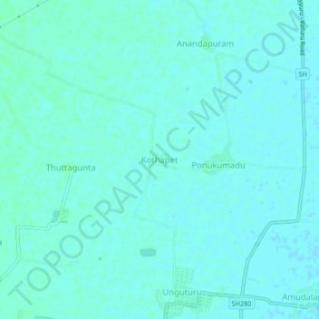
Name: Kothapet topographic map, elevation, terrain.
Location: Kothapet, Unguturu, Krishna, Andhra Pradesh, 521109, India (16.51044 80.86216 16.55044 80.90216)
Average elevation: 30 ft
Minimum elevation: 23 ft
Maximum elevation: 39 ft
Other topographic maps
Click on a map to view its topography, its elevation and its terrain.
Tarigopula
India > Andhra Pradesh > Unguturu
Tarigopula, Unguturu, Krishna District, Andhra Pradesh, 521311, India
Average elevation: 39 ft
Manikonda
India > Andhra Pradesh > Unguturu
Manikonda, Unguturu, Krishna, Andhra Pradesh, 521164, India
Average elevation: 39 ft