
Nossegem topographic map
Interactive map
Click on the map to display elevation.
About this map
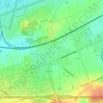
Name: Nossegem topographic map, elevation, terrain.
Location: Nossegem, Zaventem, Halle-Vilvoorde, Vlaams-Brabant, België (50.86938 4.49288 50.89330 4.52504)
Average elevation: 187 ft
Minimum elevation: 121 ft
Maximum elevation: 262 ft
Other topographic maps
Click on a map to view its topography, its elevation and its terrain.
Sterrebeek
België > Vlaams-Brabant > Halle-Vilvoorde > Zaventem
Sterrebeek, Zaventem, Halle-Vilvoorde, Vlaams-Brabant, 1933, België
Average elevation: 236 ft
Sint-Stevens-Woluwe
België > Vlaams-Brabant > Halle-Vilvoorde > Zaventem
Sint-Stevens-Woluwe, Zaventem, Halle-Vilvoorde, Vlaams-Brabant, 1932, België
Average elevation: 194 ft