
Sipi Falls - Simba topographic map
Interactive map
Click on the map to display elevation.
About this map
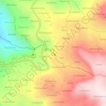
Name: Sipi Falls - Simba topographic map, elevation, terrain.
Location: Sipi Falls - Simba, Kapchorwa, Eastern Region, Ouganda (1.33710 34.38478 1.33720 34.38488)
Average elevation: 6,083 ft
Minimum elevation: 4,951 ft
Maximum elevation: 6,870 ft
Other topographic maps
Click on a map to view its topography, its elevation and its terrain.