Geolocate

Thrybergh topographic map

Click on the map to display elevation.

About this map

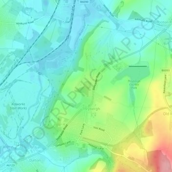
Name: Thrybergh topographic map, elevation, terrain.

Location: Thrybergh, Rotherham, South Yorkshire, England, United Kingdom (53.44022 -1.31933 53.47167 -1.27965)

Average elevation: 157 ft

Minimum elevation: 52 ft

Maximum elevation: 459 ft

Other topographic maps

Click on a map to view its topography, its elevation and its terrain.

Aston

United Kingdom > England > Rotherham

Average elevation: 292 ft

Gear up for your next adventure:

📶Vehicle Signal Boosters - Improve reception in rural areas while driving to trailheads
🎒Waterproof Dry Bags - Keep your electronics and maps dry inside your pack
🪶Thermal Camp Blanket - Extra warmth for cold nights
📡GPS Antenna Upgrade - Enhance GPS reception in remote terrain
😴Insulated Sleeping Pads - Compact and warm pads for high-elevation camping

As an Amazon Associate, this site earns from qualifying purchases at no extra cost to you.