
Thank you for supporting this site ❤️
Make a donation
Make a donation
Gear up for your next adventure:
As an Amazon Associate, this site earns from qualifying purchases at no extra cost to you.
Odón topographic map
Click on the map to display elevation.
Thank you for supporting this site ❤️
Make a donation
Make a donation
Gear up for your next adventure:
As an Amazon Associate, this site earns from qualifying purchases at no extra cost to you.
About this map
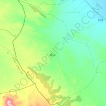
Name: Odón topographic map, elevation, terrain.
Location: Odón, Jiloca, Teruel, Aragon, 50373, Spain (40.82880 -1.62597 40.94373 -1.50656)
Average elevation: 3,635 ft
Minimum elevation: 3,274 ft
Maximum elevation: 4,577 ft
Thank you for supporting this site ❤️
Make a donation
Make a donation
Gear up for your next adventure:
As an Amazon Associate, this site earns from qualifying purchases at no extra cost to you.