
Landkreis München topographic map
Interactive map
Click on the map to display elevation.
About this map
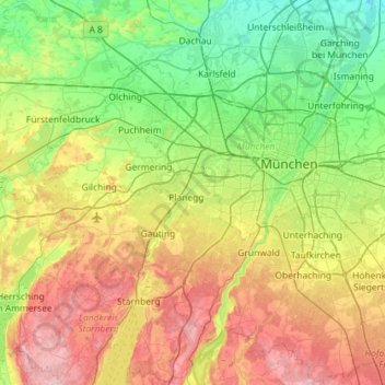
Name: Landkreis München topographic map, elevation, terrain.
Location: Landkreis München, Bayern, Deutschland (47.91593 11.38515 48.29919 11.85209)
Average elevation: 1,847 ft
Minimum elevation: 1,509 ft
Maximum elevation: 2,477 ft
Other topographic maps
Click on a map to view its topography, its elevation and its terrain.
Oberhaching
Deutschland > Bayern > Landkreis München
Oberhaching, Landkreis München, Bayern, Deutschland
Average elevation: 1,991 ft
Oberschleißheim
Deutschland > Bayern > Landkreis München
Oberschleißheim, Landkreis München, Bayern, 85764, Deutschland
Average elevation: 1,588 ft
Garching bei München
Deutschland > Bayern > Landkreis München
Garching bei München, Landkreis München, Bayern, 85748, Deutschland
Average elevation: 1,585 ft