
Make a donation
Gear up for your next adventure:
As an Amazon Associate, this site earns from qualifying purchases at no extra cost to you.
Itapevi topographic map
Click on the map to display elevation.
Make a donation
Gear up for your next adventure:
As an Amazon Associate, this site earns from qualifying purchases at no extra cost to you.
Itapevi
In 1912, Joaquim Nunes Filho (Nho Quim), from Cotia city, purchased the Sítio Itapevy, with 152 bushels. This place covering all the current city center. Nunes became a local political boss, for his ties to the former PRP (Partido Republicano Paulista). He managed the elevation of the village to district Cotia on October 12, 1920; Nunes has brought electricity in 1929 and the installation of the first telephone in 1930.
Make a donation
Gear up for your next adventure:
As an Amazon Associate, this site earns from qualifying purchases at no extra cost to you.
About this map
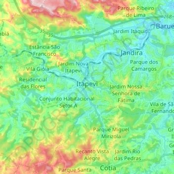
Name: Itapevi topographic map, elevation, terrain.
Average elevation: 2,671 ft
Minimum elevation: 2,365 ft
Maximum elevation: 3,435 ft
Make a donation
Gear up for your next adventure:
As an Amazon Associate, this site earns from qualifying purchases at no extra cost to you.
Other topographic maps
Click on a map to view its topography, its elevation and its terrain.
São Paulo
Brazil > São Paulo > Região Metropolitana de São Paulo > São Paulo
São Paulo is in Southeastern Brazil, in southeastern São Paulo State, approximately halfway between Curitiba and Rio de Janeiro. The city is on a plateau placed beyond the Serra do Mar (Portuguese for "Sea Range" or "Coastal Range"), itself a component of the vast region known as the Brazilian Highlands,…
Average elevation: 2,575 ft
Praça Tenente Roberto Osaki
Brazil > São Paulo > Região Metropolitana de São Paulo > Osasco
Average elevation: 2,398 ft
Praça Bartolomeu de Messina
Brazil > São Paulo > Região Metropolitana de São Paulo > São Paulo
Average elevation: 2,592 ft
Sitio Borda da Mata
Brazil > São Paulo > Região Metropolitana de São Paulo > Franco da Rocha
Average elevation: 2,602 ft
Make a donation
Gear up for your next adventure:
As an Amazon Associate, this site earns from qualifying purchases at no extra cost to you.
Santo André
Brazil > São Paulo > Região Metropolitana de São Paulo > Santo André
Average elevation: 2,546 ft
São Bernardo do Campo
Brazil > São Paulo > Região Metropolitana de São Paulo > São Bernardo do Campo
Average elevation: 2,493 ft