Geolocate

Decatur topographic map

Click on the map to display elevation.

About this map

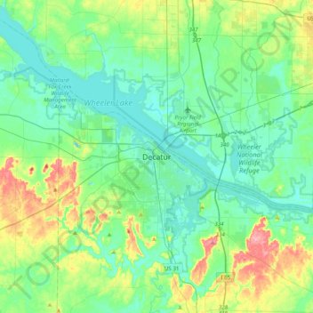
Name: Decatur topographic map, elevation, terrain.

Location: Decatur, Morgan County, Alabama, 35602, United States (34.44602 -87.14382 34.76602 -86.82382)

Average elevation: 623 ft

Minimum elevation: 538 ft

Maximum elevation: 892 ft

Morgan County trails, hiking, mountain biking, running and outdoor activities

Gear up for your next adventure:

🔥Fast-Boil Camping Stoves - Efficient cooking systems for quick trail meals
🌧️Backpack Rain Cover - Keep gear dry in wet weather
🦶Carbon Trekking Poles - Reduce knee impact on steep descents with ultra-light poles
🛶Inflatable Kayak - Portable kayak for rivers, lakes, and expeditions
😴Insulated Sleeping Pads - Compact and warm pads for high-elevation camping

As an Amazon Associate, this site earns from qualifying purchases at no extra cost to you.