
Make a donation
Gear up for your next adventure:
As an Amazon Associate, this site earns from qualifying purchases at no extra cost to you.
Lagares topographic map
Click on the map to display elevation.
Make a donation
Gear up for your next adventure:
As an Amazon Associate, this site earns from qualifying purchases at no extra cost to you.
About this map
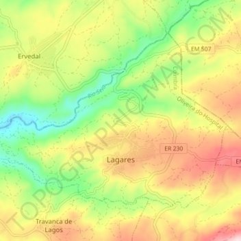
Name: Lagares topographic map, elevation, terrain.
Location: Lagares, Oliveira do Hospital, Coimbra, Portugal (40.38869 -7.90206 40.42741 -7.83197)
Average elevation: 1,165 ft
Minimum elevation: 712 ft
Maximum elevation: 1,677 ft
Make a donation
Gear up for your next adventure:
As an Amazon Associate, this site earns from qualifying purchases at no extra cost to you.
Other topographic maps
Click on a map to view its topography, its elevation and its terrain.
Insua
Portugal > Coimbra > Santa Ovaia e Vila Pouca da Beira > Vila Pouca da Beira
Average elevation: 1,378 ft
Make a donation
Gear up for your next adventure:
As an Amazon Associate, this site earns from qualifying purchases at no extra cost to you.