
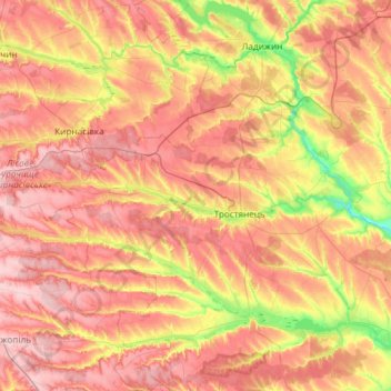
Trostianets Settlement Hromada topographic map
Interactive map
Click on the map to display elevation.
About this map
Name: Trostianets Settlement Hromada topographic map, elevation, terrain.
Average elevation: 758 ft
Minimum elevation: 456 ft
Maximum elevation: 997 ft
Other topographic maps
Click on a map to view its topography, its elevation and its terrain.
Desna
Desna, Vinnytsia Urban Hromada, Vinnytsia Raion, Vinnytsia Oblast, 23240, Ukraine
Average elevation: 843 ft
Havryshivka
Havryshivka, Vinnytsia Urban Hromada, Vinnytsia Raion, Vinnytsia Oblast, 23202, Ukraine
Average elevation: 925 ft
Salnyk
Salnyk, Kalynivka Urban Hromada, Khmilnyk Raion, Vinnytsia Oblast, Ukraine
Average elevation: 866 ft
Demivka
Demivka, Olhopil Rural Hromada, Haisyn Raion, Vinnytsia Oblast, 24832, Ukraine
Average elevation: 495 ft
Urozhaine
Urozhaine, Hnivan Urban Hromada, Vinnytsia Raion, Vinnytsia Oblast, Ukraine
Average elevation: 876 ft
Sharhorod
Sharhorod, Sharhorod Urban Hromada, Zhmerynka Raion, Vinnytsia Oblast, Ukraine
Average elevation: 889 ft
Koziatyn
Koziatyn, Koziatyn Urban Hromada, Khmilnyk Raion, Vinnytsia Oblast, Ukraine
Average elevation: 961 ft
Illintsi
Illintsi, Illintsi Urban Hromada, Vinnytsia Raion, Vinnytsia Oblast, 22700, Ukraine
Average elevation: 741 ft
Medvidka
Medvidka, Stryzhavka Settlement Hromada, Vinnytsia Raion, Vinnytsia Oblast, 23216, Ukraine
Average elevation: 814 ft
Vinnytsia
Vinnytsia, Vinnytsia Urban Hromada, Vinnytsia Raion, Vinnytsia Oblast, Ukraine
Average elevation: 899 ft
Haisyn
Haisyn, Haisyn Urban Hromada, Haisyn Raion, Vinnytsia Oblast, 23700, Ukraine
Average elevation: 663 ft
Strilchyntsi
Strilchyntsi, Nemyriv Urban Hromada, Vinnytsia Raion, Vinnytsia Oblast, 22843, Ukraine
Average elevation: 814 ft
Maidan-Chapelskyi
Maidan-Chapelskyi, Luka-Meleshkivska Rural Hromada, Vinnytsia Raion, Vinnytsia Oblast, Ukraine
Average elevation: 1,017 ft
Topolivka
Topolivka, Krasnopilka Rural Hromada, Haisyn Raion, Vinnytsia Oblast, 23811, Ukraine
Average elevation: 771 ft
Tomashpil
Ukraine > Vinnytsia Oblast > Tomashpil
Tomashpil, Tomashpil Settlement Hromada, Tulchyn Raion, Vinnytsia Oblast, 24200, Ukraine
Average elevation: 860 ft
Pohrebysche
Ukraine > Vinnytsia Oblast > Pohrebysche
Pohrebysche, Pohrebyshche Raion, Vinnytsia Oblast, Ukraine
Average elevation: 787 ft
Sob
Sob, Illintsi Raion, Vinnytsia Oblast, 22552, Ukraine
Average elevation: 804 ft
Velykyi Step
Ukraine > Vinnytsia Oblast > Velykyi Step
Velykyi Step, Koziatyn Raion, Vinnytsia Oblast, Ukraine
Average elevation: 1,017 ft
Lystopadivka
Ukraine > Vinnytsia Oblast > Lystopadivka
Lystopadivka, Листопадівка, Makhnivka Rural Hromada, Khmilnyk Raion, Vinnytsia Oblast, 22112, Ukraine
Average elevation: 1,001 ft
Vinnytsia
Ukraine > Vinnytsia Oblast > Vinnytsia
Vinnytsia, Vinnytsia Oblast, 21000-21499, Ukraine
Average elevation: 892 ft